Picture 1 of 2

Gallery
Picture 1 of 2


Have one to sell?
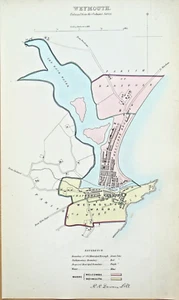
Antique Map WEYMOUTH DORSET Original Town and Street Plan Dawson 1832

GBP 35.00
ApproximatelyUS $46.18
Condition:
“used”
- Buy It NowAntique Map WEYMOUTH DORSET Original Town and Street Plan Dawson 1832
Oops! Looks like we're having trouble connecting to our server.
Refresh your browser window to try again.
Shipping:
GBP 18.50 (approx US $24.41) Royal Mail International Tracked.
Located in: Shrewsbury, United Kingdom
Delivery:
Estimated between Thu, Nov 6 and Wed, Nov 19 to 94104
Returns:
30 days returns. Buyer pays for return shipping. If you use an eBay shipping label, it will be deducted from your refund amount.
Payments:
Earn up to 5x points when you use your eBay Mastercard®. Learn moreabout earning points with eBay Mastercard
Shop with confidence
Seller assumes all responsibility for this listing.
eBay item number:176588339582
Item specifics
- Seller Notes
- “used”
- Country of Origin
- United Kingdom
- Date Range
- 1800-1899
- Type
- Political Map
- Printing Technique
- Lithography
- Format
- Sheet Map
- Year
- 1832
- Era
- 1800s
- Cartographer/Publisher
- Dawson
- Original/Reproduction
- Antique Original
- Country/Region
- England
- County
- Dorset
Item description from the seller

Popular categories from this store
Seller feedback (19,062)
- e***l (494)- Feedback left by buyer.Past 6 monthsVerified purchaseVery nice map in good condition as described. Dispatched quickly and very securely packaged. Prices seem fair when compared to many others about the web. Highly recommended!Antique Map ENGLAND, Saxon Heptarchy SAXTON & HOLE, Camden Original 1637 (#177044832868)
- l***s (7108)- Feedback left by buyer.Past 6 monthsVerified purchaseLovely item, as described, immaculately packed and swiftly delivered - recommended seller 👍GREAT YARMOUTH, NORFOLK, Street Plan, Dawson Original antique map 1832 (#123914835478)
- g***a (4289)- Feedback left by buyer.Past 6 monthsVerified purchaseGoods exactly as described, good communications – recommended sellerSUSSEX, JAMES WYLD Chichester, Brighton, Petworth Folding antique map 1865 (#176819350288)
More to explore :
- Antique European Maps & Atlases Dorset,
- Antique European Maps & Atlases England Dorset,
- Cape Town Antique Original Antique African Maps & Atlases,
- Antique European Maps & Atlases Dorset 1800-1899 Date Range,
- Antique Original Political Map Antique Wall Maps,
- Antique Original Topographical Map Antique Wall Maps,
- Antique Original Geological Map Antique Atlas Maps,
- Antique Original Geological Map Antique Folding Maps,
- Antique Original River Map Antique Atlas Maps,
- Antique Original City Map Antique Folding Maps
Popular categories from this store
Seller feedback (19,062)
- e***l (494)- Feedback left by buyer.Past 6 monthsVerified purchaseVery nice map in good condition as described. Dispatched quickly and very securely packaged. Prices seem fair when compared to many others about the web. Highly recommended!Antique Map ENGLAND, Saxon Heptarchy SAXTON & HOLE, Camden Original 1637 (#177044832868)
- l***s (7108)- Feedback left by buyer.Past 6 monthsVerified purchaseLovely item, as described, immaculately packed and swiftly delivered - recommended seller 👍GREAT YARMOUTH, NORFOLK, Street Plan, Dawson Original antique map 1832 (#123914835478)
- g***a (4289)- Feedback left by buyer.Past 6 monthsVerified purchaseGoods exactly as described, good communications – recommended sellerSUSSEX, JAMES WYLD Chichester, Brighton, Petworth Folding antique map 1865 (#176819350288)