Picture 1 of 3


Gallery
Picture 1 of 3


Have one to sell?
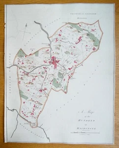
Antique Map MAIDSTONE HUNDRED KENT, Boxley, Detling, Linton, Loose, Hasted 1782

GBP 135.00
ApproximatelyUS $177.69
Condition:
“used”
- Buy It NowAntique Map MAIDSTONE HUNDRED KENT, Boxley, Detling, Linton, Loose, Hasted 1782
Oops! Looks like we're having trouble connecting to our server.
Refresh your browser window to try again.
Returns:
30 days returns. Buyer pays for return shipping. If you use an eBay shipping label, it will be deducted from your refund amount.
Payments:
Earn up to 5x points when you use your eBay Mastercard®. Learn moreabout earning points with eBay Mastercard
Shop with confidence
Seller assumes all responsibility for this listing.
eBay item number:176255528457
Item specifics
- Seller Notes
- “used”
- Country of Origin
- United Kingdom
- Antique
- Yes
- Date Range
- 1700-1799
- Type
- County Map
- Printing Technique
- Copper Plate
- Format
- Sheet Map
- Year
- 1782
- Era
- 1700s
- Cartographer/Publisher
- Edward Hasted
- Original/Reproduction
- Antique Original
- Country/Region
- England, United Kingdom, British Isles
- County
- Kent
Item description from the seller

Popular categories from this store
Seller feedback (19,067)
- n***6 (1505)- Feedback left by buyer.Past monthVerified purchaseFast delivery, item as described, nice map, good service
- e***l (496)- Feedback left by buyer.Past 6 monthsVerified purchaseVery nice map in good condition as described. Dispatched quickly and very securely packaged. Prices seem fair when compared to many others about the web. Highly recommended!Antique Map ENGLAND, Saxon Heptarchy SAXTON & HOLE, Camden Original 1637 (#177044832868)
- l***s (7117)- Feedback left by buyer.Past 6 monthsVerified purchaseLovely item, as described, immaculately packed and swiftly delivered - recommended seller 👍GREAT YARMOUTH, NORFOLK, Street Plan, Dawson Original antique map 1832 (#123914835478)
More to explore :
- Antique European Maps & Atlases Kent,
- Kent Antique Original Antique European Maps & Atlases,
- Antique European Maps & Atlases England Kent,
- England Kent Antique Original Antique European Maps & Atlases,
- Antique European Maps & Atlases Kent 1800-1899 Date Range,
- England Kent Antique Europe Maps & Atlases 1800-1899 Date Range,
- Antique Atlas Maps,
- Antique Original Nautical Map Antique Folding Maps,
- Antique Original Railroad Map Antique Wall Maps,
- Antique Original Physical Map Antique Sheet Maps
Popular categories from this store
Seller feedback (19,067)
- n***6 (1505)- Feedback left by buyer.Past monthVerified purchaseFast delivery, item as described, nice map, good service
- e***l (496)- Feedback left by buyer.Past 6 monthsVerified purchaseVery nice map in good condition as described. Dispatched quickly and very securely packaged. Prices seem fair when compared to many others about the web. Highly recommended!Antique Map ENGLAND, Saxon Heptarchy SAXTON & HOLE, Camden Original 1637 (#177044832868)
- l***s (7117)- Feedback left by buyer.Past 6 monthsVerified purchaseLovely item, as described, immaculately packed and swiftly delivered - recommended seller 👍GREAT YARMOUTH, NORFOLK, Street Plan, Dawson Original antique map 1832 (#123914835478)