
Picture 1 of 2

Picture 1 of 2


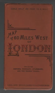
1890 Map of 60 Miles West Of London Gall And Inglis London & Edinburgh Vintage

GBP 49.99
ApproximatelyUS $62.30
Condition:
“Map in Excellent Condition - no rips or tears - See Image of actual item for sale”
Shipping:
GBP 20.29 (approx US $25.28) Expedited Shipping to United States via eBay's Global Shipping Program. See detailsfor shipping
Located in: Worcester, United Kingdom
Import charges:
Free amount confirmed at checkout
Delivery:
Estimated between Thu, May 16 and Thu, May 23 to 43230
Includes international tracking
Returns:
Payments:
Earn up to 5x points when you use your eBay Mastercard®. Learn moreabout earning points with eBay Mastercard
Shop with confidence
Seller assumes all responsibility for this listing.
eBay item number:166668814773
Item specifics
- Seller Notes
- “Map in Excellent Condition - no rips or tears - See Image of actual item for sale”
- Date Range
- 1800-1899
- Type
- Ordnance Survey Map
- Format
- Folding Sheet Map
- Year
- 1890
- Era
- 1800s
- Cartographer/Publisher
- Gall And Inglis London & Edinburgh
- Original/Reproduction
- Vintage Original
- Material
- Paper
- Scale
- Half Inch to One Statute Mile
- Country/Region
- England, United Kingdom
- County
- Buckinghamshire, Hertfordshire, Surrey
- Edition
- Includes Oxford, Newbury, Aylesbury and the Thames Valley
Item description from the seller
Seller assumes all responsibility for this listing.
eBay item number:166668814773
Shipping and handling
Item location:
Worcester, United Kingdom
Ships to:
Antigua and Barbuda, Aruba, Australia, Austria, Bahamas, Bahrain, Bangladesh, Barbados, Belgium, Belize, Bermuda, Bolivia, Brazil, Brunei Darussalam, Bulgaria, Cambodia, Canada, Cayman Islands, Chile, China, Colombia, Costa Rica, Cyprus, Czech Republic, Denmark, Dominica, Dominican Republic, Ecuador, Egypt, El Salvador, Estonia, Finland, France, French Guiana, Germany, Gibraltar, Greece, Grenada, Guadeloupe, Guatemala, Guernsey, Honduras, Hong Kong, Hungary, Iceland, Indonesia, Ireland, Israel, Italy, Jamaica, Japan, Jersey, Jordan, Kuwait, Latvia, Liechtenstein, Lithuania, Luxembourg, Macau, Malaysia, Maldives, Malta, Martinique, Mexico, Monaco, Montserrat, Netherlands, New Zealand, Nicaragua, Norway, Oman, Pakistan, Panama, Paraguay, Peru, Philippines, Poland, Portugal, Qatar, Republic of Croatia, Reunion, Romania, Saint Kitts-Nevis, Saint Lucia, Saudi Arabia, Singapore, Slovakia, Slovenia, South Africa, South Korea, Spain, Sri Lanka, Sweden, Switzerland, Taiwan, Thailand, Trinidad and Tobago, Turks and Caicos Islands, Ukraine, United Arab Emirates, United Kingdom, United States, Uruguay, Vietnam
Excludes:
PO Box, Afghanistan, Libya, Nauru, Russian Federation, Somalia, Yemen
| Shipping and handling | Import charges | To | Service | Delivery*See Delivery notes |
|---|---|---|---|---|
| GBP 20.29 (approx US $25.28) | See import charges at checkout | United States | Expedited Shipping (International Priority Shipping) | Estimated between Thu, May 16 and Thu, May 23 to 43230 |
| Handling time |
|---|
| Will ship within 7 business days of receiving cleared payment. The seller has specified an extended handling time for this item. |
| Taxes |
|---|
| Taxes may be applicable at checkout. Learn moreLearn more about paying tax on eBay purchases. |
Return policy
| Return policy details |
|---|
| Seller does not accept returns |
Refer to eBay Return policyopens in a new tab or window for more details. You are covered by the eBay Money Back Guaranteeopens in a new tab or window if you receive an item that is not as described in the listing.
Payment details
Payment methods

Popular categories from this store
Seller feedback (17,950)
i***t (517)- Feedback left by buyer.
Past year
Verified purchase
The items were well packed and arrived quickly. the items were as described. great communication with the seller. Great ebayer.
h***e (278)- Feedback left by buyer.
Past month
Verified purchase
Fast delivery. Item as described and very well packed . Highly recommended seller. Thankyou very much.
s***8- Feedback left by buyer.
Past 6 months
Verified purchase
Absolute excellent transaction! Excellent communication, well graded, fast shipping, superb packaging! Thanks a lot!
More to explore :
- London London Antique Europe Sheet Maps,
- London London Antique Europe Folding Maps,
- London London Antique Europe County Maps,
- Antique European Maps & Atlases London London,
- London London Antique Europe City Maps,
- London United Kingdom European Antique London Maps & Atlases,
- London Antique Europe City Maps,
- London Antique Europe Folding Maps,
- London Antique European Maps & Atlases London 1900-1909 Date Range,
- London England Antique Europe City Maps