Picture 1 of 8


Gallery
Picture 1 of 8


Have one to sell?
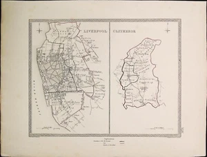
Collection of 8 Antique Maps of Lancashire

GBP 89.99
ApproximatelyUS $120.83
or Best Offer
Condition:
“Mixed condition. Some with foxing, some staining and small tears in the margins. Creases where they ”... Read moreabout condition
- Buy It NowCollection of 8 Antique Maps of Lancashire
Oops! Looks like we're having trouble connecting to our server.
Refresh your browser window to try again.
Shipping:
GBP 18.50 (approx US $24.84) Royal Mail International Tracked.
Located in: Worthing, West Sussex, United Kingdom
Delivery:
Estimated between Mon, Oct 27 and Fri, Nov 7 to 94104
Returns:
30 days returns. Buyer pays for return shipping. If you use an eBay shipping label, it will be deducted from your refund amount.
Payments:
Earn up to 5x points when you use your eBay Mastercard®. Learn moreabout earning points with eBay Mastercard
Shop with confidence
Seller assumes all responsibility for this listing.
eBay item number:156272712268
Item specifics
- Seller Notes
- Antique
- Yes
- Date Range
- 1800-1899
- Type
- County Map
- Year
- Multiple years
- Era
- 1800s
- Cartographer/Publisher
- John Cary and Others
- Original/Reproduction
- Antique Original
- County
- Lancashire
Item description from the seller

Seller feedback (7,576)
- s***a (2088)- Feedback left by buyer.Past 6 monthsVerified purchaseGood seller. Items as described. Prompt shipping. Packed well. Post office folded the large envelope, but stamps came through okay. Thank you.Stock Sheet of Mint Ireland Stamps in Blocks (#157080779817)
- r***6 (843)- Feedback left by buyer.Past monthVerified purchaseVery highly recommended seller. Fast delivery. Well packed. Accurate description. Perfect!
- 2***h (1639)- Feedback left by buyer.Past 6 monthsVerified purchaseArrived safe and sound and packaged quite nicely. A great item from a great eBay seller and brilliant communication throughout. Thank you very much for a perfect transaction. A competent and trusted seller you can rely on here.South African Military Belt, WWI or II (#155667552427)
More to explore :
- Antique European Maps & Atlases Lancashire,
- Lancashire Antique Original Antique European Maps & Atlases,
- Antique European Maps & Atlases England Lancashire,
- Antique European Maps & Atlases Lancashire 1800-1899 Date Range,
- England European Antique Maps & Atlases Lancashire 1800-1899 Date Range,
- Antique Atlas Maps,
- Antique Original Political Map Antique Wall Maps,
- Antique Original Topographical Map Antique Wall Maps,
- Antique Original County Map Antique Atlas Maps,
- Antique Original City Map Antique Sheet Maps
Seller feedback (7,576)
- s***a (2088)- Feedback left by buyer.Past 6 monthsVerified purchaseGood seller. Items as described. Prompt shipping. Packed well. Post office folded the large envelope, but stamps came through okay. Thank you.Stock Sheet of Mint Ireland Stamps in Blocks (#157080779817)
- r***6 (843)- Feedback left by buyer.Past monthVerified purchaseVery highly recommended seller. Fast delivery. Well packed. Accurate description. Perfect!
- 2***h (1639)- Feedback left by buyer.Past 6 monthsVerified purchaseArrived safe and sound and packaged quite nicely. A great item from a great eBay seller and brilliant communication throughout. Thank you very much for a perfect transaction. A competent and trusted seller you can rely on here.South African Military Belt, WWI or II (#155667552427)