Picture 1 of 2

Picture 1 of 2


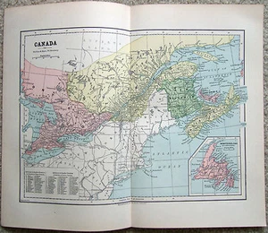
Eastern Canada - Original 1882 Map by Phillips & Hunt. Antique

US $16.00
Condition:
“A bit of age toning, minor wear and one center fold as issued, otherwise this rare map is in very ”... Read moreabout condition
Shipping:
Free USPS Ground Advantage®.
Located in: Sayville, New York, United States
Delivery:
Estimated between Fri, Sep 27 and Mon, Sep 30 to 43230
Returns:
30 days returns. Seller pays for return shipping.
Payments:
Special financing available. See terms and apply now- for PayPal Credit, opens in a new window or tab
Earn up to 5x points when you use your eBay Mastercard®. Learn moreabout earning points with eBay Mastercard
Shop with confidence
Seller assumes all responsibility for this listing.
eBay item number:134906112778
Item specifics
- Seller Notes
- Date Range
- 1800-1899
- Type
- Map
- Format
- Atlas Map
- Printing Technique
- Lithography
- Canadian Province
- New Brunswick, Newfoundland & Labrador, Nova Scotia, Ontario, Prince Edward Island, Quebec
- Year
- 1882
- Original/Reproduction
- Antique Original
- Cartographer/Publisher
- Phillips & Hunt
- Country/Region
- Canada
- Maker
- Phillips & Hunt
Item description from the seller

More to explore :
- Eastern Hemisphere Antique Original Antique World Physical Maps,
- Eastern Hemisphere Antique Original Antique World Sheet Maps,
- Eastern Hemisphere Antique Original Antique World Atlas Maps,
- Canada Antique Original Antique North America Maps & Atlases,
- Canada Antique Original Antique North America Railroad Maps,
- Antique Original Topographical Map Antique Wall Maps,
- Antique Original Railroad Map Antique Sheet Maps,
- Antique Original Middle Eastern Antiques,
- Antique Original Sword Middle Eastern Antiques,
- Antique Original City Map Antique Sheet Maps