Picture 1 of 1
Stock photo

Picture 1 of 1
Stock photo
National Geographic Reference Map Ser.: Continental Divide - National Geographic by National Geographic Maps - Reference (2018, Sheet Map, Folded)

ZUBER (290438)
98.5% positive feedback
Price:
$67.49
Free shipping
Returns:
30 days returns. Seller pays for return shipping.
Condition:
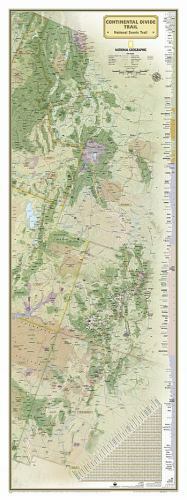
NATIONAL GEOGRAPHIC: CONTINENTAL DIVIDE TRAIL WALL MAP - LAMINATED (18 X 48 INCHES) (NATIONAL GEOGRAPHIC REFERENCE MAP) By National Geographic Maps - Reference **BRAND NEW**.
- Buy It NowNATIONAL GEOGRAPHIC: CONTINENTAL DIVIDE TRAIL WALL MAP - By National Geographic
Oops! Looks like we're having trouble connecting to our server.
Refresh your browser window to try again.
About this product
Product Identifiers
PublisherNational Geographic Maps
ISBN-101566957478
ISBN-139781566957472
eBay Product ID (ePID)242438892
Product Key Features
Number of Pages1 Pages
LanguageEnglish
Publication NameContinental Divide-National Geographic
Publication Year2018
SubjectTravel, Reference, Science, Earth Sciences / Geography, United States / General, Atlases, Gazetteers & Maps (See Also Travel / Maps & Road Atlases)
TypeMap
AuthorNational Geographic Maps-Reference
SeriesNational Geographic Reference Map Ser.
FormatSheet Map, Folded
Dimensions
Item Weight3 Oz
Item Length48 in
Item Width18 in
Additional Product Features
Edition Number2017
Intended AudienceTrade
IllustratedYes
SynopsisExpertly researched and designed, National Geographic's map of the Continental Divide Trail is ideal for fans and hikers of this magnificent National Scenic Trail. It makes a great planning tool or as reference to track progress on the 3,100 plus mile length. This beautiful map shows the entire length of the trail from Mexico to Canada through New Mexico, Colorado, Wyoming, Idaho, and Montana. A unique elevation profile highlights the trail's peaks and valleys, and an informative mileage chart shows the distance between key locations. Also highlighted on this map are passes, peaks, national forests, national parks, state parks, and Indian reservations. Additional points of interest include lodges and campgrounds near the trail. The map is encapsulated in heavy-duty 1.6 mil laminate which makes the paper much more durable and resistant to the swelling and shrinking caused by changes in humidity. Laminated maps can be framed without the need for glass, so the frames can be much lighter and less expensive. Map Scale = 1:1,900,000 Sheet Size = 18" x 48", National Geographic's map of the Continental Divide Trail is ideal for fans and hikers of this magnificent National Scenic Trail. It makes a great planning tool or as reference to track progress on the 3,100 plus mile length. This beautiful map shows the entire length of the trail from Mexico to Canada through New Mexico, Colorado, Wyoming, Idaho, and Montana. A unique elevation profile highlights the trail's peaks and valleys, and an informative mileage chart shows the distance between key locations. Also highlighted on this map are passes, peaks, national forests, national parks, state parks, and Indian reservations. Additional points of interest include lodges and campgrounds near the trail The map is encapsulated in heavy-duty 1.6 mil laminate which makes the paper much more durable and resistant to the swelling and shrinking caused by changes in humidity. Laminated maps can be framed without the need for glass, so the fames can be much lighter and less expensive., National Geographic's map of the Continental Divide Trail is ideal for fans and hikers of this magnificent National Scenic Trail. It makes a great planning tool or as reference to track progress on the 3,100 plus mile length. This beautiful map shows the entire length of the trail from Mexico to Canada through New Mexico, Colorado, Wyoming, Idaho, and Montana. A unique elevation profile highlights the trail's peaks and valleys, and an informative mileage chart shows the distance between key locations. Also highlighted on this map are passes, peaks, national forests, national parks, state parks, and Indian reservations. Additional points of interest include lodges and campgrounds near the trail. The map is encapsulated in heavy-duty 1.6 mil laminate which makes the paper much more durable and resistant to the swelling and shrinking caused by changes in humidity. Laminated maps can be framed without the need for glass, so the fames can be much lighter and less expensive. Map Scale = 1:1,900,000 Sheet Size = 18" x 48"
Be the first to write a review


